Azores
A stunning archipelago of nine volcanic islands
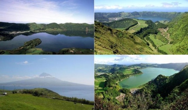
located 1500 km (900 mi) of mainland Portugal. The Azores are the peer of Western Europe, has some of the highest mountains on the planet hidden beneath the Atlantic Ocean as the Pico which has 2351 m (7711ft) above sea level. All the islands are extremely beautiful, with coasts of cavernous cliffs, rocky outcrops, black sand beaches and sheltered bays. There are traces of massive volcanic eruptions, craggy mountains with deep ravines, lakes, craters and rock formations contrast with the eternal green of the plain. The islands vary greatly in size from 17 km2 of the Corvo (7 sq mi) to São Miguel with 759 km2 (295 sq mi). Each of the islands has its own characteristics, history and architecture. The Azores were inhabited when the Portuguese arrived in 1439. São Miguel and Santa Maria are the easternmost islands, Ponta Delgada, capital of São Miguel is the largest city in the Azores, has a fantastic architecture. Terceira (means third in Portuguese) has this name because it was the third to be colonized. The nine islands have a great marine diversity, is often seen whales and dolphins. Do not miss Lagoa das Sete Cidades (Seven Cities Lagoon), the city of Angra do Heroismo, World Heritage Site by UNESCO, Ribeira Grande and the highest mountain of Portugal (Pico). Hotels in Azores
Islands of Azores: São Miguel; Santa Maria; Terceira; São Jorge; Faial; Pico; Corvo; Flores; Graciosa;
Main Cities: Ponta Delgada; Angra do Heroísmo; Horta;
Transports in Azores
Airports: There are four airports in Azores, João Paulo II in São Miguel Island (PDL), Santa Maria Airport (SMA), Horta Airport in Faial Island (HOR) and the Lajes Airport in Terceira Island (TER). There are flights from Lisbon, Oporto and Madeira. There are also flights from some european cities.
Ferry: There are ferry boat trips between the islands especially during the summer.
Map of Azores
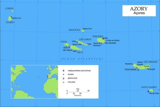
Azores Map